

近日的Blog上,ㄟㄟㄟ常會出現一些英文地名啦和英文介紹啦,看起來很有深度的樣子。
不過真的要拜網路的Blog盛行,有的時候只要有些線索。
用些關鍵地名搜尋,在配合上一些Blog遊記畫面,從那些圖片來喚起記憶,確認識自己走過個路徑。
像是那天~首先是隨意的走著。
一樣的看見羊就忍不住下車,拍羊~一樣是超可愛。
很有鏡頭概念,會看鏡頭勒。
之後照片顯示,在雨霧中穿過了一大彎彎曲曲,很陡峭很荒涼的山路。
真的是頗難開的山路。
似乎是什麼冰河時期侵蝕過的遺跡。
沿路有著長長的綿延不斷的漆黑石塊堆成的矮石牆。
儼然像是一個矮小的[萬里長城]一般。
不知知道這陡峭又狹小山路路徑是什麼名稱。
當初也是莫名其妙開進去的山路。

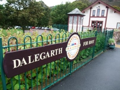
只知道下了綿延的山路後,後來來到了,一個可以乘坐迷你版SL火車的車站。
車站名稱是DALEGARTH。
用這站名去搜尋,發現這條觀光火車路線是[Ravenglass & Eskdale Railway]。
而剛好有個日本人也走了同樣的路徑來到這車站。
於是根據他的紀錄,判斷那穿過高山險峻蜿蜒山路,像是國家地理頻道會出現畫面的路段,應該是稱作[Hardknott Pass]

只知道下了綿延的山路後,後來來到了,一個可以乘坐迷你版Sl的火車的車站。
車站名稱是代爾加斯。
用這站名去搜尋,發現這條觀光火車路線是[雷文格拉斯與埃斯克代爾鐵路
]。
而剛好有個日本人也走了同樣的路徑來到這車站。
於是根據他的紀錄,判斷那穿過高山險峻蜿蜒山路,像是國家地理頻道會出現畫面的路段,應該是稱作 [Hardknott通行證]
英文說明如下,似乎是羅馬時期就有的路徑。
Hardknott Pass is a pass that carries a minor road between Eskdale and the Duddon Valley in the county of Cumbria, England, in the Lake District National Park. The road approaching the pass vies with Rosedale Chimney Bank in North Yorkshire for the title of steepest road in England with both achieving a gradient of 1 in 3 (about 33%).
The Romans originally built a road over the pass in the 2nd century AD to link the coastal fort at Ravenglass with their garrisons at Ambleside and Kendal. The Romans called this road the Tenth Highway. It reaches a height of 393 m (1289 ft) at the top of the Hardknott Pass before descending steeply to the Duddon Valley and then ascending and descending the Wrynose Pass (also 393 m) on its way to Ambleside. The road fell into disrepair after the Romans left Britain in the early part of the 5th century AD, although it remained as an unpaved packhorse route throughout the centuries.

The Ministry of Defence used the area for tank training during the Second World War and this completely destroyed the ancient track. After the War a decision was made to repair the damage and rebuild the road with a tarmac surface to give a direct motor route between Ambleside and Eskdale for the first time. However, the Roman route and the modern road do not generally coincide, the Roman route lying generally to the north of the modern road west of the summit, and to the south on the other side.
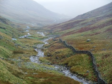
日文稱為 [ハードノット峠]。
沒有留言:
張貼留言